Plate Boundaries
It is thought that
the crust, underneath the
oceans as well as the continents, together with the upper part of
the mantle is divided into huge 'rafts' called plates. The
movement of the plates will be explained
below. Amongst these plates
there are 8 major ones and assortment of smaller ones. The major
plates include the following: 1. The African
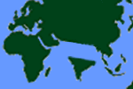
plate The diagrams
below indicates the different plates on the world map which shows
that the plates are capped by both the oceanic and continental crust.
Most volcanoes are found around and along the plate edges. Constructive - plates separating Destructive - plates colliding Conservative - plates sliding past each other. Constructive
plate movement - This happens when tectonic plates move apart, magma rises up to bridge the
gap and produces new crust made
of igneous rock, basalt. sometimes magma comes out
with great force producing undersea volcanoes. This is quite evident in the middle
of Atlantic Ocean. The so called Mid-Atlantic
ridge runs the whole length of the Atlantic and actually cuts through the middle of Iceland,
which is why they have hot underground water.
As the magma rises up through the gap
it forms ridges, and underwater
mountains, resulting in symmetrical
pattern either side of the ridge, thus providing strong evidence for the theory of continental drift (see animation above). The most convincing evidence, however, comes from the magnetic direction of the rocks. As the liquid magma erupts out of the gaps, the iron particles
in the rocks tend to align themselves with the Earth's magnetic field and as it cools they set in position. Earth’s magnetic field shift: Normal and reversed polarity diagram Every 500,000 years or so the earth's magnetic
field tend to switch direction.
This means the rock on either side of the
ridge has bands of alternate magnetic
polarity. This pattern is found to be Symmetrical either
side of the ridge (see animation below). Destructive
plate movement - This occurs when plates
move towards each other. Different types of collision
may take place at these boundaries. Oceanic and Continental plates or two continental plates can collide with each other. Oceanic and Continental plates colliding:
Since the oceanic plate is more dense, it is always forced underneath the continental
plate. This is called subduction (see animation below). As the oceanic plate is pushed down a deep
trench is formed. The plate melts and creates pressure in the surrounding
area due to all the melting rock. The resulting molten
rock finds its way to the surface and volcanoes form. Earthquakes also happen as the two plates slowly grind past each other. The continental crust is not destroyed. It is simply compressed, folded into anticlines and synclines and thickened to form a fold
mountain range similar to the Andes in South America.
Two continental plates colliding: When two continental
plates collide head on, neither of them is subducted.
Instead the sediment layers laying
between the two continent land masses get squeezed.
The effect is to form fold mountains similar to the Himalayas.
This type of fold mountain range has no volcanoes or deep focus earthquakes. India, in fact detached it self from Africa and piled into
the bottom of Asia. It is
still doing so, pushing the Himalayas up and up. This means Mount
Everest is getting taller by a few centimeters every year as India continues to push up into
the continent of Asia. Himalayan mountain formation Conservative
plate movement: When plates
slide past each other this type of movement results.
Here, material is neither created or destroyed.
The best known example of this is the San
Andres Fault in California (see animation below). It
marks the boundary between the Pacific plate and the North American plate.
These plates of rock don't glide smoothly past each other, they catch on each other and as the forces
build up they suddenly jerk.
This sudden jerking only lasts a few seconds,
but brings devastation in a built-up
and heavily populated areas. The city of San Francisco sits along side this type of fault line. It was completely destroyed in 1906 and was again hit by
a powerful tremor in 1991.
This could happen again any time.
These days in earthquake
zones, developers try to build earthquake-proof
buildings which are designed to withstand small amount of shaking.
In poorer countries, earthquakes
usually cause much devastation where they have badly constructed properties, overcrowding and inadequate
rescue services. You may also be interested in: SITES Title URL VolcanoWorld MTU's Volcanoes Page USGS Cascades Volcanoes Observatory Global Volcanism Network USGS Volcanoes Site 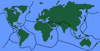
The
Earth's Surface
 Side-by-side comparison of Earth with and without tectonic plate boundaries
2.
The Antarctic
plate
3.
The Indoaustralian
plate
4.
The Eurasian
plate
5.
The Nazca plate
6.
The North American
plate
7.
The Pacific
plate
8.
The South American
plate World map of major tectonic plates and plate boundaries
There
are 3 types of plate
movements.
 Cross-section diagram of a mid-ocean ridge and rising magma

 Mid-ocean ridge magnetic striping and sea-floor spreading diagram
Mid-Atlantic Ridge Cross-section diagram of a subduction zone

 Cross-section diagram of a transform plate boundary
Test your knowledge of how tectonic plates interact at different types of boundaries. 1. At which type of boundary do tectonic plates move away from each other? 2. What is created at a destructive boundary when the oceanic plate is forced downwards? 3. Why do volcanoes NOT usually form at conservative plate boundaries? 4. What happens when plates become "stuck" at a conservative boundary? 5. Which type of volcano is commonly found at constructive boundaries?🌍 Knowledge Check: Plate Boundaries
Click to Reveal Answers
2. An ocean trench (Formed where the oceanic plate subducts under the continental plate).
3. No rising magma (Plates only slide past each other without creating gaps or melting).
4. Pressure builds up (The release of this stored energy causes earthquakes).
5. Shield volcanoes (Formed by magma rising to fill the gap between plates).
Tags: Plate Tectonics, Earthquakes, Volcanoes, Constructive, Destructive, Conservative, continents moving, earthquake plates map, names of tectonic plates, plate tectonic evidence